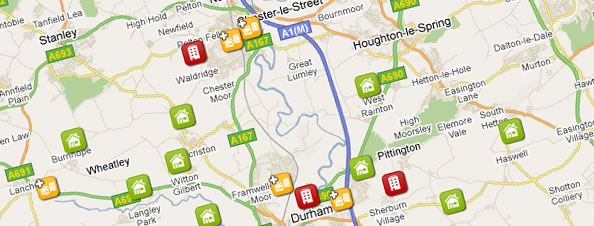
We were recently presented with the challenge of replacing Cathedral Lettings’ existing property mapping software with a solution of our own. What this involved was pulling out a list of properties and their information from the Aspasia property management software feed that powers the information on the whole Cathedral website.
This provides us with information such as prices, availability, descriptions and imagery for each individual property. It also gives us an exact longitude and latitude for their location which is what lets us plot the properties so accurately on the map.
The main functionality of the map includes searching by postcode, filtering by number of bedrooms and price per calendar month. Clickable property icons are then displayed in their exact location on the map depending on whether they are houses or flats. Upon clicking these icons, the viewer is presented with a quick summary of the property which then clicks through to the full property information page.
Probably the most difficult aspect of the map to integrate was the grouping the property icons where properties are too close to distinguish geographically. This was especially important to Cathedral Lettings as some properties, such as flats, are in the same building which would lead to individual icons sitting on top of each other. Clustering icons within a certain geographical threshold allows us to display the information for all of the properties even if they are in identical positions on the map.
The final feature that we implemented was the use of a new feature in the Google Maps API, Street View, to display a street level panoramic view of the property. Again, this is based on the actual geolocation of the property which offers us close to 100% accuracy. This allows to visitor to take a virtual walk down the street that the property is on. They can also zoom in to get a closer view of the property’s features.